
Ansan Jarak-gil Trail 안산자락길 & Ansan Mountain 안산
-
Free
-
Dongnimmun Station (line 3, exit 4). Turn right upon exit.


There are signs leading to Ansan Jarak-gil. Walk towards the right side of Lee Jin Ah Memorial Library and follow the signs to enter Ansan Jarak-gil Trail.
💡 Alternatively, if you prefer to walk on the road, take exit 5 from the station. Go straight upon exit, turn left at the first junction and walk all the way uphill until you see the long stairs up to Ansan Jarak-gil on your right.
2-2.5 hrs on the 7km circular trail around the mountain. Optional path to summit (additional 30-45 mins).
A 'Hidden' Hiking Gem, Seoul
Ansan Jarak-gil Trail is probably the best-kept secret hiking trail in Seoul! Located in Seodaemun-gu, its nearest subway station is only one stop away from the popular Gyeongbokgung (Palace) Station.
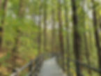
At Ansan Jarak-gil, 7km of raised wooden deck trail encircles the entire circumference of the Ansan Mountain that can be completed in 2.5 hrs.
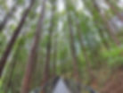
Ansan Jarak-gil is the country's first barrier-free mountain walking trail with gentle slopes, allowing visitors of all ages, young or old to experience walking through the woods.
Ansan Jarak-gil is also accessible to those using wheelchairs and baby carriages entering near Seodaemun-gu Office. A wheelchair charger can be seen at this entrance as well.
Ansan Mountain Comparing with Bukhansan National Park & Cheonggyesan Mountain
If you have been putting off getting up to the highest peak (836.5m) at Bukhansan National Park holding on to ropes and chains; or the much easier peak (582.5m) but still a tedious uphill hike of Cheonggyesan Mountain, you can definitely give Ansan Mountain's summit a try.
At an altitude of 296m, Ansan Mountain is relatively low compared to other mountains in Korea and yet you can still enjoy the sights and scenes of a Seoul's mountain.

Multiple Walking Trails with Option to Ansan Mountain Summit
There are several entry and exit points to Ansan Jarak-gil raised wooden deck trail.
From Ansan Jarak-gil, there are again multiple dirt trails leading to the summit of Ansan Beacon Mound (296m) in 30-45 mins. There are trails that are shorter in distance but steeper ascend to the summit, or you can take the longer route with gradual ascend.
Of course, if height is not for you, you can always stay on Ansan Jarak-gil (raised wooden deck trail) without having to make the ascend to the summit.


Suggested Walking & Hiking Courses
For overseas visitors to Seoul, it is recommended to start Ansan Jarak-gil Trail from Dongnimmun Station for its proximity and clear direction signs to Ansan Jarak-gil (raised wooden deck). Also, you can visit the nearby Yeongcheon Market for its many famous food and Seodaemun Prison with its original forms of jail.
On the trail, you can either return to the same starting point by doing a complete loop walk or you can exit on the other side of the mountain to Yonsei University campus, located in Sinchon Shopping District with subway access.


Hiking Courses:
a) Food Lovers Course
🚉Dongnimmun Station ➜ 🍩Yeongcheon Market ➜ 🌲Ansan Jarak-gil ➜ 🍜Sinchon Shopping Street (exit Yonsei University) ➜ 🚉Sinchon Station
b) Korean History Seekers Course
🚉Dongnimmun Station ➜ 🕊Seodaemun Independence Park ➜ ⛓Seodaemun Prison History Hall (Museum) ➜ 🌲Ansan Jarak-gil ➜ 🎓exit Yonsei University ➜ 🚉Sinchon Station
c) Complete Loop Perfectionists Course
🚉Dongnimmun Station ➜ 🌲Ansan Jarak-gil (full loop) ➜ 🍩Yeongcheon Market (optional but recommended) ➜ 🕊Seodaemun Independence Park (optional) ➜ ⛓Seodaemun Prison History Hall (optional) ➜ 🚉Dongnimmun Station
d) See It All Challengers Course
🚉Dongnimmun Station ➜ 🍩Yeongcheon Market ➜ 🕊Seodaemun Independence Park ➜ ⛓Seodaemun Prison History Hall (Museum) ➜ 🌲Ansan Jarak-gil ➜ ⛰Ansan Beacon Mound Summit ➜ 🎓exit Yonsei University ➜ 🍜Sinchon Shopping Street ➜ 🚉Sinchon Station
'See It All Challengers' Course - Sights, Scenes & Directions
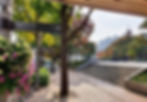
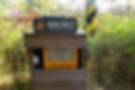
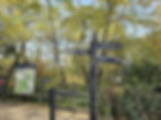
Once you have visited the attractions near Dongnimmun Station (i.e. Yeongcheon Market, Seodaemun Independence Park and Seodaemun Prison History Hall), follow the 'Ansan Jarak-gil' signs to Lee Jina Memorial Library at Seodaemun Independence Park.
💡Not often, however, if you come across any Korean only sign, you can use Google Translate app by pointing your phone at the Korean signage🤳 and use the camera feature on the app for instant language translation.
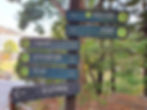

Enter the path at the side of Lee Jina Memorial Library
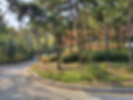
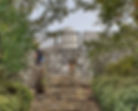
The path is easy to follow as there are signs along the way and there is only one route. The path will eventually lead you to a road. From the road, you will be able see the raised wooden deck ahead, the entrance to Ansan Jarak-gil.


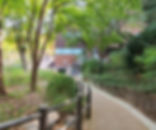

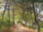


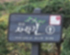
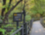
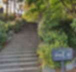
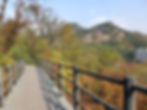
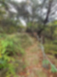
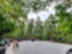
Enter Ansan Jarak-gil Trail
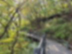
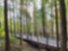
Get on the final flight of stairs and you will reach Ansan Jarak-gil raised wooden deck!🤸♀️ Turn right towards Book Cafe Rest Area. Enjoy the forest and scenic view along the way.
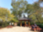
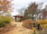
💡 Turn left and walk in the clockwise direction of Ansan Jarak-gil will lead you to Neunganjeong Pavilion.


A break stop at Book Cafe Rest Area with nearby toilet before ascending to Ansan Summit.
Book Cafe Rest Area
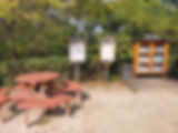
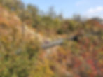
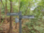
💡 Before reaching Book Cafe Rest Area, there is a Muakjae Sky-Bridge crossing on your right that links Ansan Mountain to Inwangsan Mountain across the road traffic below.


💡Continue on Ansan Jarark-gil walking past Book Cafe Rest Area instead of ascending the summit will lead you to Jarak-gil Observatory, a rest area with scenic view of both Inwangsan and Bukhansan Mountains.


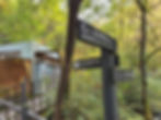
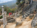
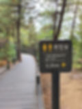
Start Ascend to Ansan Beacon Mound Summit (Total time to summit: 30-45mins)
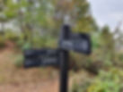
Follow the sign near the toilet for 'Ansan (Mt.) Top'. This is a shorter but steep route (with stairs) to the summit.


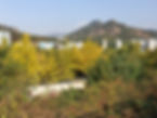
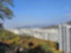
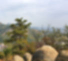
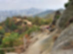
Mid-way View (lower)
Nice pleasing view of the buildings (Seodaemun-gu) below and the mountain range beyond.🤗
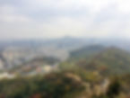
The mountain at the center is Inwangsan Mountain (338.2m). On its left is Bukhansan Mountain (836.5m) and Bugaksan (Baegaksan) Mountain (342m) on its right.
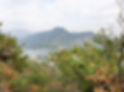
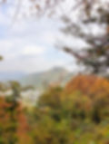
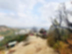
Mid-way View (Upper)
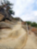
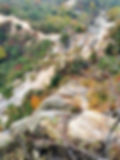
From the mid-point, you can clearly see the rocky mountainside trail and the Beacon Mound summit at the top.
The journey to the summit may seem a bit daunting from this view point. However, once you continue on, it is not as intimidating as it looks.


Final Lap to Beacon Mound Summit
Interestingly, the final lap to the summit is relatively easy.


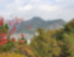
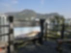
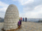
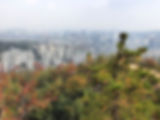
Summit of Ansan Mountain - Beacon Mound (Altitude of 296m)
The summit of Ansan Mountain is also referred as Bongsudae. Ansan Bongsudae is a beacon fire station where the beacon mounds were used to send military smoke signals in Joseon Dynasty (1392-1910).


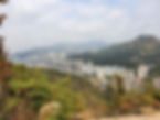
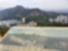
From Bongsudae, you will be rewarded with spectacular view of Seoul with sights of Inwangsan Mountain, Seoul City Wall (Hanyangdoseong), Bukhansan Mountain, Bugaksan Mountain, Namsan Mountain and N Seoul Tower.😍

From this vantage point, you can see the rocky mountainside trail between the mid-point and summit.

Descend from Ansan Summit
Next, we shall get down Ansan Summit to the mid point, using the same trail up earlier. This is the first and easy section of the descend.
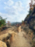
Continue Descend on Rocky Mountainside Trail
Beautiful view on the descend.


Mid-way on the descend, take a slight detour on the stairs up leading to an observatory.


Another memorable panoramic view of Seoul...💗


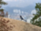
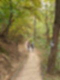
View of people getting on the rocky mountainside trail. 🧗


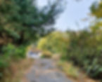
Continue descend to Mid-point & onwards to Baegam Mineral Spring
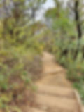
At the base of the rocky mountainside trail (mid-point), follow the sign to Baegam Mineral Spring and continue descend towards Metasequoia Forest.


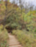

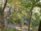
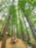
Metasequoia Forest on the Dirt Trail
Along the dirt trail, look out for a long stretch of stairs, Metasequoia Stairs going straight downwards on your right. The Metasequoia Stairs will lead you to Metasequoia Forest and eventually back to Ansan Jarak-gil (i.e. raised wooden deck).
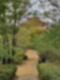
At the Metasequoia Forest Rest Area, take a moment to relish the breathtaking sight of Metasequoia trees reaching towards the sky in a most tranquil and unforgettable setting.


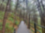
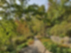
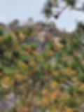
Pine Nut Trees along Ansan Jarak-gil
Back on Ansan Jarak-gil, continue on your left to Pine Nut Forest.


Metasequoia Trees along Ansan Jarak-gil
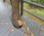
You will get to see the tall Metasequoia Trees along Ansan Jarak-gil trail as well. At times, you may get to see a tree trunk poking out interestingly from the raised wooden deck.


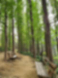
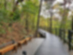
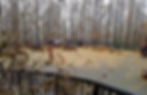
Rest Area & Forest Stage
Along Ansan Jarak-gil, visitors can take a rest on the benches or at the big Forest Stage.
Exit Ansan Jarak-gil to Yonsei University 연세대학교
After passing Forest Stage, look out for signs to Yonsei University. Exit Ansan Jark-gil and follow the dirt trail to the university campus.
This would complete our Ansan Jarak-gil and summit hiking course.


Seasonal Highlights at Ansan Mountain & Ansan Jarak-gil
a) Spring
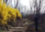
Spring brings along the popular Cherry Blossoms and yellow Forsythia flowers.


Ansan Mountain is a different scene again in winter, offering visitors a distinct experience on each visit and new trails ventured.
b) Winter


Attractions Around Yonsei University
When exiting to Yonsei University, do check out its three Gothic-style buildings, a photo hot spot for many visitors to the university. Another university, Ewha Womans Univserity is within walking distance away with nearby Sinchon Shopping Street.


Map of walking path from Dongnimmun Station to the start of Ansan Jarak-gil Trail

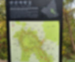
Map of Mountain Ansan Jarak-gil Trail

Map of Attractions around Ansan Jarak-gil Trail

KoreaToDo TOP PICKS - Tours, Activities & Discount Tickets
➥ Handpicked experiences by KoreaToDo for their uniqueness, value, popularity, price competitiveness and at times, tedious to reach by public transport.


♔ KoreaToDo recommends Klook.com, Asia leading in-destination service provider.

❀SEASONAL HIGHLIGHTS❀ Handpicked Experiences


Other KoreaToDo Collection that you may like:
-
Bukhansan National Park - The most visited National Park in Korea with the highest peak at 836.5m
-
Cheonggyesan (Mountain) - Walk on well-paved road all the way to the summit at 582m
-
Seoul City Wall Hike (Naksan Mountain Trail) - Easy walking trail alongside Seoul City Wall, passing through Ihwa Mural Village and Naksan Park.
-
Scenic Hiking Trails